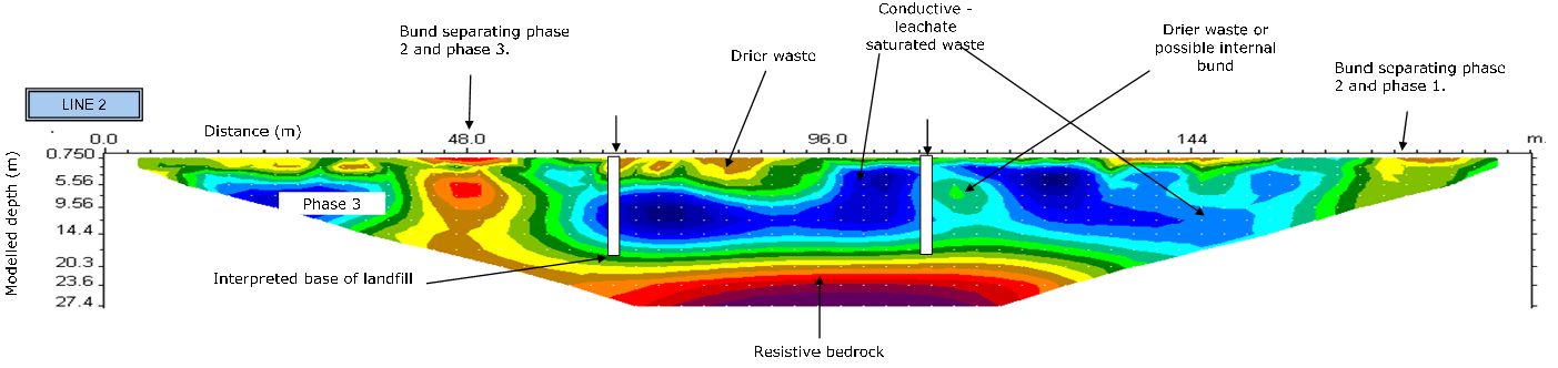
Geophysical Surveys
A Geophysical survey is the systematic collection of geo physical data for spatial analysis studies which can tell us more about what is beneath the surface the study was conducted over.
Why would you perform Geophysical Surveys?
Exploration for-
- Groundwater
- Dykes
- Orebody's
- Contamination plumes and sources
- Human Artifacts
Monitoring of-
- Contamination Plumes
- Other Environmental and engineering issues
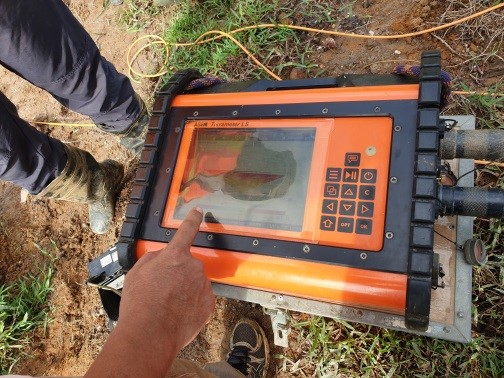
Advantages of Geophysical Surveys
- Non-destructive.
- Efficient way of evaluating large areas rapidly.
- Comprehensiveness as a combination of methods can be used to solve complex problems.
- Cost-effective as with upper surface investigations, no excavation or drilling is needed.
- The science and technology is proven and majority of techniques have been used for more than half a century.
Types of Geophysical Methods include:
- Resistivity
- Magnetic
- Electro magnetic
- Gravity
Water Quality Assessment and Monitoring
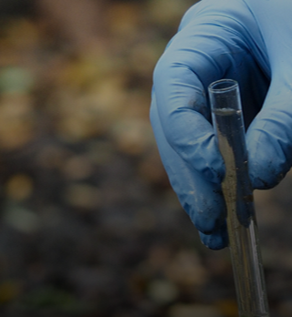
Water quality is not only of interest for human consumption, but also for environmental reasons. Water bodies may need to be monitored as it could effect the ecology of an area, livestock or human health. It can in some cases identify probable sources of pollution.
Why would you perform water quality assessment and monitoring?
- To determine the water composition and what usage risks the body of water may have for the intended usage.
- Monitoring of water quality is of importance as it can serve as objective evidence to make sound decisions to better manage water resources for now and future generations. This in turn can ensure sustainability of the resource whilst mitigating risks.
Advantages of water quality assessment and monitoring
- Protection of users against possible health risks and other negative effects caused by poor water quality.
- It can alert us to ongoing, current and emerging dangers or problems through monitoring of compliance and standards.
Borehole Pumping Tests and Hydrocensus
Pumping tests are field experiments where a Borehole is pumped at a controlled rate, a water level response known as drawdown is measured in that borehole, or surrounding observation wells if available. From the data responses, hydraulic properties of aquifer system can be determined and well performance and aquifer boundaries can be estimated.
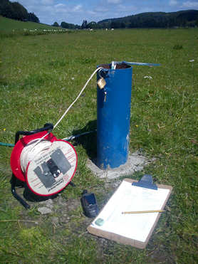
Why you should perform borehole-pumping tests on a borehole.
- Generally, there are two main objectives to carry out a pumping test number one is to estimate sustainable Yield and hydraulic performance if the individual boreholes are for water supply. Two to establish aquifer potential, assess the hydraulic characteristics of the aquifer, and determine groundwater resources. Contamination sources can also possibly be identified with risk assessments, contamination sources could possibly cause harm. This in turn increases sustainability of the resource being used.
Advantages of performing borehole-pumping tests
- Determining sustainable yields which in turn can be used to avoid long-term depletion of boreholes which helps maintain the ecosystem stability and function.
- Well efficiency can possibly be increased.
- A better understanding of groundwater resources leading to more efficient usage and less loss or risk of the resource.
Low cost alternative is a Slug test (technically not a pump test but can be used to identify some aquifer characteristics) Slug test are used due to time and financial constraints, or boreholes being inaccessible to pumps and to get a relative baseline for the pumping tests.
This alternative is suggested only in rare cases and is not as reliable as a full pumping test.
Need a Borehole?
We can assist with reliable drillers if you need a borehole drilled on your property, we also prefer to use scientific equipment to aid in borehole placement for possibly larger yeilds, and we can assist with pump recommendations, rates and more.
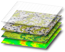
Geo Data Analysis
Geo Data Analysis has proven highly proficient for evaluating of geographic suitability of certain locations for specific purposes, Estimating and predicting outcomes, assisting in interpretation and understanding of change, and detecting important patterns not necessarily seen.
Geo Data can be analyzed through spatial (space) and temporal (time) distribution or even as Spatiotemporal, which refers to analysis of data, which was collected across both space and time. Multiple events can be measured and compared to indicate trends and more.
This in turn can help solving problems before they arise which can mitigate risks or even estimate potential yields.
Types of Geo Data Analysis-
- Orebody modelling and estimation
- Resource estimation
- Groundwater exploration
- Monitoring of water quality
- Contamination plume delineations
Why one would perform Geo Data Analysis
- To better understand the environment.
- Determine whether something such as mining is financially feasible.
- To identify possible trends and minimize risk.
- To determine ideal locations for specific features or processes.
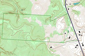
Mapping Services
Maps can be used in a variety of different ways, from navigation, to establishing ownership, to presenting information. We use Geographic Information Systems (GIS) to perform the Art of map-making to an accurate resolution for usage by our client’s Needs
Advantages of Using Maps
- Maps help to present information.
- Maps provide visual interpretation, which is often easier to understand .
- Maps can be used to display current and predicted values or features.
- The use of maps can display elements to better grasp the effects and influential criteria of an area or process.
- Utilizes left and right hemispheres of the brain.
- Helps aid in evaluations of risk and usage potentials.
Our Services
Select our services below to view more
Geophysical Surveys
A Geophysical survey is the systematic collection of geo physical data for spatial analysis studies which can tell us more about what is beneath the surface the study was conducted over.
Why would you perform Geophysical Surveys?
Exploration for-
- Groundwater
- Dykes
- Orebody's
- Contamination plumes and sources
- Human Artifacts
Monitoring of-
- Contamination Plumes
- Other Environmental and engineering issues
Advantages of Geophysical Surveys
- Non-destructive.
- Efficient way of evaluating large areas rapidly.
- Comprehensiveness as a combination of methods can be used to solve complex problems.
- Cost-effective as with upper surface investigations, no excavation or drilling is needed.
- The science and technology is proven and majority of techniques have been used for more than half a century.
Types of Geophysical Methods include:
- Resistivity
- Magnetic
- Electro magnetic
- Gravity
Water Quality Assessment and Monitoring
Water quality is not only of interest for human consumption, but also for environmental reasons. Water bodies may need to be monitored as it could effect the ecology of an area, livestock or human health. It can in some cases identify probable sources of pollution.
Why would you perform water quality assessment and monitoring?
- To determine the water composition and what usage risks the body of water may have for the intended usage.
- Monitoring of water quality is of importance as it can serve as objective evidence to make sound decisions to better manage water resources for now and future generations. This in turn can ensure sustainability of the resource whilst mitigating risks.
Advantages of water quality assessment and monitoring
- Protection of users against possible health risks and other negative effects caused by poor water quality.
- It can alert us to ongoing, current and emerging dangers or problems through monitoring of compliance and standards.
Borehole Pumping Tests and Hydrocensus
Pumping tests are field experiments where a Borehole is pumped at a controlled rate, a water level response known as drawdown is measured in that borehole, or surrounding observation wells if available. From the data responses, hydraulic properties of aquifer system can be determined and well performance and aquifer boundaries can be estimated.
Why you should perform borehole-pumping tests on a borehole.
- Generally, there are two main objectives to carry out a pumping test number one is to estimate sustainable Yield and hydraulic performance if the individual boreholes are for water supply. Two to establish aquifer potential, assess the hydraulic characteristics of the aquifer, and determine groundwater resources. Contamination sources can also possibly be identified with risk assessments, contamination sources could possibly cause harm. This in turn increases sustainability of the resource being used.
Advantages of performing borehole-pumping tests
- Determining sustainable yields which in turn can be used to avoid long-term depletion of boreholes which helps maintain the ecosystem stability and function.
- Well efficiency can possibly be increased.
- A better understanding of groundwater resources leading to more efficient usage and less loss or risk of the resource.
Low cost alternative is a Slug test (technically not a pump test but can be used to identify some aquifer characteristics) Slug test are used due to time and financial constraints, or boreholes being inaccessible to pumps and to get a relative baseline for the pumping tests.
This alternative is suggested only in rare cases and is not as reliable as a full pumping test.
Need a Borehole?
We can assist with reliable drillers if you need a borehole drilled on your property, we also prefer to use scientific equipment to aid in borehole placement for possibly larger yeilds, and we can assist with pump recommendations, rates and more.
Geo Data Analysis
Geo Data Analysis has proven highly proficient for evaluating of geographic suitability of certain locations for specific purposes, Estimating and predicting outcomes, assisting in interpretation and understanding of change, and detecting important patterns not necessarily seen.
Geo Data can be analyzed through spatial (space) and temporal (time) distribution or even as Spatiotemporal, which refers to analysis of data, which was collected across both space and time. Multiple events can be measured and compared to indicate trends and more.
This in turn can help solving problems before they arise which can mitigate risks or even estimate potential yields.
Types of Geo Data Analysis-
- Orebody modelling and estimation
- Resource estimation
- Groundwater exploration
- Monitoring of water quality
- Contamination plume delineations
Why one would perform Geo Data Analysis
- To better understand the environment.
- Determine whether something such as mining is financially feasible.
- To identify possible trends and minimize risk.
- To determine ideal locations for specific features or processes.
Mapping Services
Maps can be used in a variety of different ways, from navigation, to establishing ownership, to presenting information. We use Geographic Information Systems (GIS) to perform the Art of map-making to an accurate resolution for usage by our client’s Needs
Advantages of Using Maps
- Maps help to present information.
- Maps provide visual interpretation, which is often easier to understand .
- Maps can be used to display current and predicted values or features.
- The use of maps can display elements to better grasp the effects and influential criteria of an area or process.
- Utilizes left and right hemispheres of the brain.
- Helps aid in evaluations of risk and usage potentials.